Thursday, March 30, 2023

Week 9: Subsidence in Iceland


Subsidence is a sinking of the ground due to underground material movement. Its causes can include human interference (anthropogenic subsidence) such as removal of water and natural resources such as oil and natural gas  from the ground by means of pumping, fracking, or mining. Subsidence can also be caused by naturally occurring events including earthquakes, soil compaction,  glacial isostatic adjustment (GIA), erosion, and sinkhole formation.  It can happen anywhere in the world and it does happen in Iceland but is rarely a problem for humans due to the fact that Iceland is proactive about where they build and the country is quite sparsely populated.  


Iceland is a country that is constantly deforming.  Subsidence in this country has a number of causes such as plate spreading, GIA, volcanic, and geothermal processes. GIA is the ongoing movement of land in response to the last ice age. The following explanation from NOAA made it very clear for me so I am quoting it below in the hopes that you will also find it helpful:


Here's how it works: Imagine lying down on a soft mattress and then getting up from the same spot. You see an indentation in the mattress where your body had been, and a puffed-up area around the indentation where the mattress rose. Once you get up, the mattress takes a little time before it relaxes back to its original shape.

Even the strongest materials (including the Earth's crust) move, or deform, when enough pressure is applied. So when ice by the megaton settled on parts of the Earth for several thousand years, the ice bore down on the land beneath it, and the land rose up beyond the ice's perimeter—just like the mattress did when you lay down on and then got up off of it.

GIA is the main source of vertical deformation in Iceland while plate spreading is the main source of horizontal deformation.  

Iceland has long made use of the geothermal waters in this country so an anthropogenic cause of deformation in Iceland occurs around  the Reykjanes, Svartsengi, Hellisheidi geothermal power plants as well.  
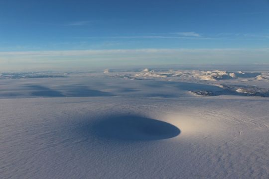

A photo of an “ice cauldron” at Bárðarbunga caldera, which scientists have surmised have probably formed due to volcanic, or geothermal activity below the surface. 


As far as mitigation measures are concerned, the Icelandic Meteorological Office constantly shares updates with the public.  The government also uses seismic monitoring, satellites,  and GPS systems to monitor the  degree of subsidence.  In addition, as I stated earlier in this post, the country is selective about development and is not a very populous country which also helps in this regard. 

Finally, I would like to share this relatively new bit of land in Iceland.(see photo below)  This piece of land is temporary as it has already experienced a great deal of subsidence, but I found it very interesting. 
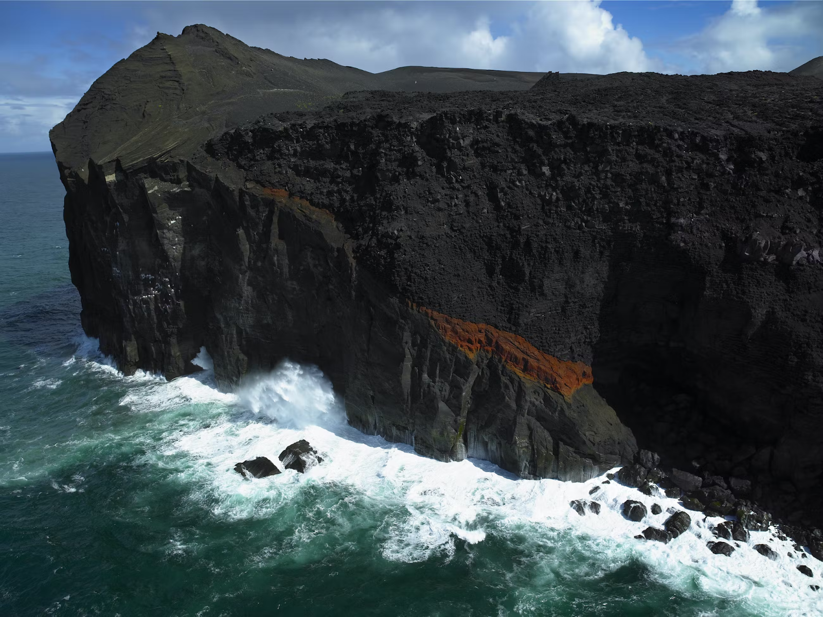

Above is a picture of Surtsey Island, which was created in a 1960 volcanic eruption. It is located on the southern coast of Iceland.   Already the island has shrunk to half of its original size due to subsidence and erosion.  Scientists predict that it will sink back below the surface sometime after the end of the current century. 


Sources:


Researchgate

https://www.researchgate.net/figure/Subsidence-in-Reykjanes-RNES-and-Svartsengi-SVAR-estimated-from-GPS-measurements_fig4_284578691


Visit Iceland

https://www.visiticeland.com/article/unesco-world-heritage


NOAA

https://oceanservice.noaa.gov/


Sunday, March 12, 2023

Week 8: Mass Wasting in Iceland


Landslide in Reyðarfjörður – Photo by Halldór G. Pétursson


Mass Wasting  is very common in Iceland, due to the terrain and a number of contributing factors, such as interaction between climate, lithology of the region, and soil erosion.  Although gravity alone can be responsible for a landslide, there are also a number of triggers in Iceland.  These triggers include: intense rainfall,  melting and retreat of the frozen landscape, changes in groundwater currents, seismic activity, and the undercutting of the land by ocean waves and glaciers. The highest landslide risk in Iceland occurs during seasonal low-pressure systems that happen in the fall bringing heavy rainfall and wind, and from the spring snow melt. 


Extent of the largest landslide where it entered the sea

.(Photo: National Commissioner's Special Forces)

     Quite recently, a landslide in Seyðisfjörður  occurred in December 2020.  This was the largest landslide to have damaged an urban area in Iceland. Fortunately no lives were lost in this event. (See photo above and outlines below)

Outlines of the December landslides in Seyðisfjörður, eastern Iceland.


There are a number of types of landslides that occur in Iceland including rockfalls, mud or debris flows, earth flows, rock slides, and gradual creep. They occur in all regions of Iceland but mostly in Central North Iceland, the East Fjords, and the West Fjords. 

Mitigation efforts are centered mostly on land use planning and creating "no build" zones. Experts are also researching the creation of better monitoring systems and the possibility of building mudslide barriers above towns that may be in danger of landslides. According to the Icelandic Meteorological Office, " Althingi ‒ the national parliament of Iceland ‒ recently approved a five-year budget plan, increasing government funding for the construction of avalanche defenses by 1.6 billion ISK annually."  Hopefully this will help expedite the creation of these defenses and increase safety for residents and tourists alike.  

  Sources:

Icelandic Meteorological Office (IMO)

https://en.vedur.is/

Icelandic Institute of Natural History

https://www.ni.is/

Tuesday, March 7, 2023

Week 7 Flooding in Iceland

   Iceland is a fairly large island situated in the middle of the North-Atlantic ocean, just south of the Arctic Circle, between 63.4°N and 66.5°N latitude. Iceland is a country that has a medium risk of coastal flooding, according to Thinkhazard.com. In order to deal with this issue before a flood, the government of Iceland has taken a number of  measures.   Building projects, including planning, design, and construction methods,  are to take into consideration the level of coastal flooding hazard in a given area and proceed accordingly. 


     “Coastal flood risks are defined by water levels and water velocity. The levels determine how much of the building from the ground up is exposed to potential damage. Water velocity is often discounted or entirely ignored although it is often responsible for as much or more damage than water contact alone. As with wind, rapidly moving flood waters can carry large and heavy debris that upon impact can cause direct physical damage. Soil scour within fast moving water can penetrate the building envelope and lead to expensive clean up costs. Be mindful of these risks by evaluating surrounding land use and potential land development in the vicinity of your project area.” 


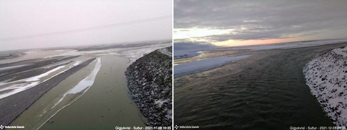
    Iceland is unique in that there are many glaciers situated directly on top of geothermal activity which can melt the glacier and  can result in glacial flooding.  This can have disastrous effects and result in a mega flood called a  Jökulhlaup which has threatened people and damaged large areas of land impacting agriculture and livestock. The most recent one occurred between November and December 2021 which is pictured below:

The water level rose substantially in the Gígjukvísl river between 28 November (left) and 1 December 2021 (right) from the jökulhlaup that began on 24 November draining the subglacial lake at Grímsvötn. View is to the S from the IMO webcam. Courtesy of IMO.


The National Weather Service gives the following information regarding what to do before a flood:


Sometimes floods develop slowly and forecasters can anticipate where a flood will happen days or weeks before it occurs. Oftentimes flash floods can occur within minutes and sometimes without any sign of rain. Being prepared can save your life and give you peace of mind.

–Create a Communications Plan

It is important to be able to communicate with your family and friends in the event of a disaster. Whether it is having a specific person identified to contact for status updates or a safe location to meet up with family members, having a plan in place will give you peace of mind if disaster does strike.

–Assemble an Emergency Kit

It is good practice to have enough food, water and medicine on hand at all times to last you at least 3 days in the case of an emergency. Water service may be interrupted or unsafe to drink and food requiring little cooking and no refrigeration may be needed if electric power is interrupted. You should also have batteries, blankets, flashlights, first aid kit, rubber boots, rubber gloves, and a NOAA Weather Radio or other battery operated radio easily available.

–Know Your Risk

Is your home, business or school in a floodplain? Where is water likely to collect on the roadways you most often travel? What is the fastest way to get to higher ground? Knowing the answers to these questions ahead of time can save your life.

–Sign Up for Notifications

The Advanced Hydrologic Prediction Service provides RSS feeds for observed forecast and alert river conditions to help keep the public informed about local water conditions

–Prepare Your Home

Sometimes floods develop slowly and forecasters can anticipate where a flood will happen days or weeks before it occurs. Oftentimes flash floods can occur within minutes and sometimes without any sign of rain. Being prepared can save your life and give you peace of mind.


1. If you have access to sandbags or other materials, use them to protect your home from flood waters if you have sufficient time to do so. Filling sandbags can take more time than you may think.

2. Have a professional install check-valves in plumbing to prevent flood waters from backing up into the drains of your home. Make sure your sump pump is working and consider having a backup. Make sure your electric circuit breakers, or fuses, are clearly marked for each area of your home.

3. Since standard homeowners insurance doesn't cover flooding, ensure coverage by contacting your insurance company or agent to purchase flood insurance. This must be done before there is even a threat of flooding as insurance companies stop issuing policies if there is a threat of flooding. (i.e. an approaching hurricane). Many flood insurance policies take at least 30 days to go into effect so even if you can buy it as a storm is approaching, it may not protect your investment.

–Prepare your Family/Pets

You may be evacuated, so pack in advance. Don't wait until the last moment to gather the essentials for yourself, your family and/or your pets.

–Charge Your Essential Electronics

Make sure your cell phone and portable radios are all charged in case you lose power or need to evacuate. Also make sure you have back-up batteries on hand.

–Leave

If it is likely your home will flood, don't wait to be ordered to leave; evacuate yourself! Make alternative plans for a place to stay. If you have pets, take them with you or make arrangements to board them at a facility well away from the flooding danger.


Thinkhazard:

https://thinkhazard.org/en/report/114-iceland/CF#:~:text=In%20the%20area%20you%20have,in%20the%20next%2010%20years.

Floodlist:

https://floodlist.com/europe/iceland-south-east-floods-september-2017


NOAA:

https://www.weather.gov/safety/flood-before

Science Direct: 

https://www.sciencedirect.com/science/article/abs/pii/S001282521930176X


The Smithsonian Institution National Museum of Natural History Global Volcanism Program:

https://volcano.si.edu/


Icelandic Meteorological Office (IMO):

https://en.vedur.is/


Monday, February 20, 2023

Week 5: Volcanoes in the Land of Fire and Ice


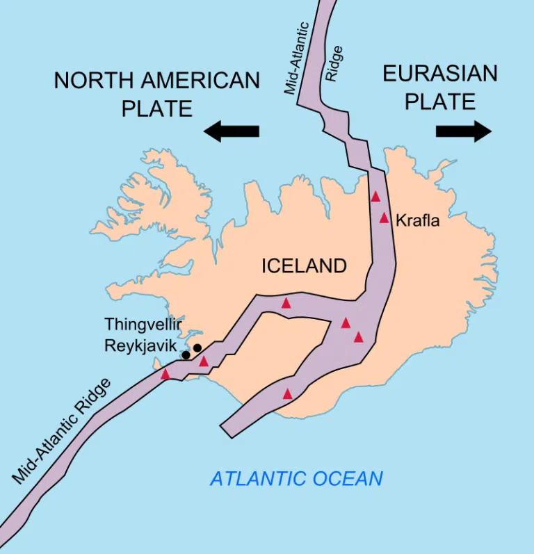
     Iceland is well known for the amount of volcanic activity that this island experiences. Iceland itself is the product of volcanism as it is situated right on top of the Mid Atlantic Ridge.  Volcanic activity actually creates the beauty of this land which is like no other. There are currently 32  (click here to see map)  active volcanoes in Iceland and volcanic tourism is a booming business here! You can book a helicopter tour, travel with a guided group tour, or even tour a volcano yourself, although the latter is not recommended. 

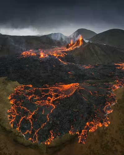
     Eruptions are very common here and most of them take place in remote areas of the highlands, or even under the very dense ice of glaciers. The most recent eruption occurred in August of 2022 when the Fagradalsfjall volcano erupted on the Reykjanes peninsula which is very near the only international airport in this country. The rift zone of the eruption was over 300 meters long with a steady flow of 20-50 square meters of lava every second when it started, according to the Icelandic Meteorological Office. There had been significant tectonic activity in the weeks leading up to this eruption and some of these temblors measured up to 5.2 on the magnitude scale.    


     Fagradalsfjall was an effusive, not eruptive, volcano which means that lava oozed out rather than exploding with rock, fire, and ash.  This made for some amazing pictures and many tourists flocked to see this amazing spectacle. Here is a short drone video of that eruption. (click here to see drone video)

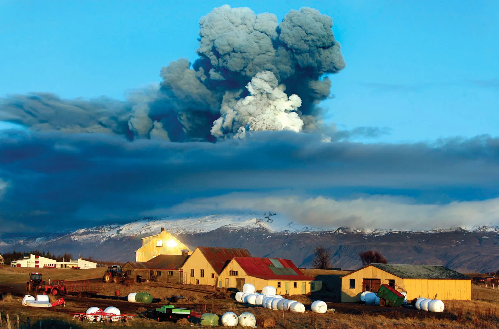
     Not all volcanic activity on this island nation is harmless though.  In 2010 the Eyajfjallajokull eruption disrupted air traffic all over Europe due to the dense ash it produced. This was a reminder of the 1783 Lakagigr eruption which caused widespread crop failure and famine in Europe because of the dense ash plume it produced. Pictured below is a photo of one of the craters left behind from this destructive eruption. 


In an area so volatile with volcanic activity it is crucial to monitor and plan what to do in the event of an eruption and the government of Iceland has many measures in place for this purpose. I found this information regarding the subject on the internet. 

"Volcanic monitoring and response

Networks of seismometers and GPS stations monitor volcanic regions around Iceland. These are mainly operated by the Icelandic Meteorological Office (IMO), providing real-time data (seismic), and same-day updates on the status of deformation at selected volcanoes (the GPS-station network). A network of real-time gauging stations in glacial rivers monitor discharge and geothermal signals in the rivers. These networks are publicly accessible on the web-page of IMO (https://vedur.is). The IMO also has C- and X-band radars to track eruption plumes. Air quality and gas concentrations are monitored by the Environment Agency of Iceland. During unrest and volcanic activity, response is coordinated by the Civil Protection Department of the Icelandic Police Commissioner. During volcanic unrest and activity, expertise is sought widely and active collaboration on monitoring and assessment exists between the IMO and the Nordic Volcanological Center at the Institute of Earth Sciences, University of Iceland. An informal Science Advisory Board of the Civil Protection Department holds frequent meetings during unrest, over the last two years exclusively as online meetings."   Source: https://www.consorsegurosdigital.com/

Sources:

Iceland's Volcanoes: The Complete Guide:

https://guidetoiceland.is

Drone Footage of Fagradalsfjall eruption:

https://youtu.be/ubHRA2x8Hx8

Icelandic Meteorological Office: 

https://en.vedur.is/

Consorseguros Vista Digital:

https://www.consorsegurosdigital.com/

Catalog of Icelandic Volcanoes:

https://icelandicvolcanos.is/#

Tuesday, February 14, 2023

Week 4: Tsunami

 In Iceland, the tsunami hazard is classified as low according to the information that is currently available. This means that there is slightly more than a 2% chance of a potentially-damaging tsunami occurring in the next 50 years. Based on this information, the impact of tsunami may be considered for any activities located near the coast.

Even though there is a low risk of Tsunami, Iceland has experienced something similar.  Mini-Tsunamis caused by glacial calving are an interesting phenomenon  and are a  fairly common occurrence, but they do not cause damage or injure people because they usually happen in areas that people do not live in. Here is a quick clip of some tourists running from such an event.

Watch: Tourists flee large wave after Icelandic glacier collapse


Climate change impact: The areas at risk of tsunami will increase as global mean sea level rises. According to the IPCC (2013), global mean sea level rise depends on a variety of factors, and estimates for 2100 range from ~20 cm to nearly 1 m. However, regional changes in sea level are difficult to predict. 

Iceland’s Meteorological Office (IMO) has an early warning system and there is public outreach to inform the public as to what they should do to stay safe in the unlikely event that there is a tsunami.   I also found these instructions on Ready.gov


Survive DURING

Illustration of a person dropping to the ground, covering their head with their hands, and crawling under a table and holding on to it.

  • If there is an earthquake and you are in a tsunami area, protect yourself from the earthquake first. Drop, Cover, and Hold On. Drop to your hands and knees. Cover your head and neck with your arms. Hold on to any sturdy furniture until the shaking stops. Crawl only if you can reach a better cover, but do not go through an area with more debris.

  • When the shaking stops, if there are natural signs or official warnings of a tsunami, move immediately to a safe place as high and as far inland as possible. Listen to the authorities, but do not wait for tsunami warnings and evacuation orders.

  • If you are outside of the tsunami hazard zone and receive a warning, stay where you are unless officials tell you otherwise.

  • Leave immediately if you are told to do so. Evacuation routes often are marked by a wave with an arrow in the direction of higher ground.

  • If you are in the water, then grab onto something that floats, such as a raft or tree trunk.

  • If you are in a boat, face the direction of the waves and head out to sea. If you are in a harbor, go inland.

Sources: 

Think Hazard:

https://thinkhazard.org/


YouTube Watch: Tourists flee large wave after Icelandic glacier collapse

 https://www.euronews.com/


Government of Iceland:

https://www.government.is/


https://www.ready.gov/tsunamis


Tuesday, February 7, 2023

Week 3 Earthquakes: There's a "whole lot of shakin' goin' on" in Iceland!


Although Iceland experiences up to 500 earthquakes each week, they are typically not big

enough to be noticed by people, or  they occur far from populated areas. 

Large earthquakes are more rare but they can occur due to the fact that Iceland is

situated right on top of the Mid-Atlantic ridge, where the North American

and Eurasian plates meet at this divergent boundary.


There are two main types of earthquakes in Iceland, some of them are 

caused by volcanic activity and the others are caused

by tectonic plate movements. 


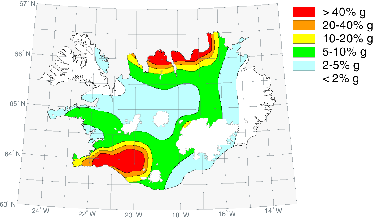
The seismicity of Iceland is shown in this map below.


Even though earthquakes are very common here,  they cause little

damage due to the quality construction of buildings and homes in this region.

This is also not a highly populated country which contributes to the low incidence

of injury or death, even in a large earthquake.

There is a great deal of research and outreach on public safety, 

from the Icelandic government which also  helps with mitigation of damages.

References: 

Icelandic Meteorological Office:

https://en.vedur.is/earthquakes-and-volcanism/earthquakes


Earthquake Engineering Research Centre:

https://eerc.hi.is/is


Everything you need to know about earthquakes in Iceland

https://traveo.is


Government of Iceland

https://www.government.is/


Tuesday, January 31, 2023

Week 2 Plate Boundaries of Iceland


It is important to understand plate boundaries in order to understand where there may be occurrences of natural hazards such as earthquakes and volcanoes.  

Iceland is situated on the Eurasian and North American Tectonic Plates, two divergent plates. Divergent plates move away from one another. Due to this,  Iceland has many earthquakes.  (see map of most recent earthquake activity below)


Along boundaries such as this, earthquakes are very common and magma rises from the earth’s core forming more land.  In fact the Eurasian and North American Plates pull this country apart by a few centimeters every year. 


 Iceland is pretty special in the world of plate tectonics, as it is one of the only places on Earth that you can see these two tectonic plates and the Mid-Atlantic Ridge above ground. (see photo below)


It is even possible to swim between two continents as is pictured below. 


Earthquakes are not the only natural hazards caused by these two plates.  Volcanic eruptions such as the Eldfell eruption in 1973, the 1783 eruption of Laki, and the 2010 eruption of Eyjafjallajokull (see photo below) were all a result of the North American and Eurasian Plates moving apart. 


References:


https://www.bluecarrental.is/


www.icelandontheweb.com


https://en.vedur.is/


https://en.wikipedia.org/wiki/Eurasian_Plate


https://www.britannica.com/place/Eyjafjallajokull-volcano


Final Hazards Iceland: Volcanoes and Extreme Weather/Storms

            Iceland is a land of many extremes and the people who inhabit this island nation must prepare for a myriad of natural hazards, i...