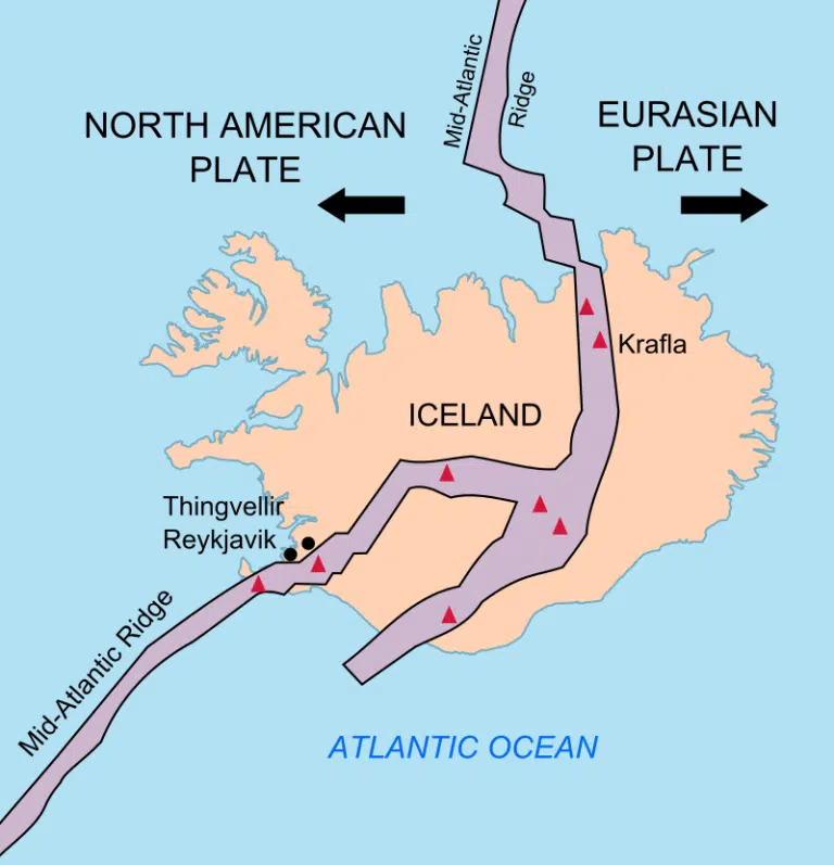
Iceland is well known for the amount of volcanic activity that this island experiences. Iceland itself is the product of volcanism as it is situated right on top of the Mid Atlantic Ridge. Volcanic activity actually creates the beauty of this land which is like no other. There are currently 32 (click here to see map) active volcanoes in Iceland and volcanic tourism is a booming business here! You can book a helicopter tour, travel with a guided group tour, or even tour a volcano yourself, although the latter is not recommended.
Eruptions are very common here and most of them take place in remote areas of the highlands, or even under the very dense ice of glaciers. The most recent eruption occurred in August of 2022 when the Fagradalsfjall volcano erupted on the Reykjanes peninsula which is very near the only international airport in this country. The rift zone of the eruption was over 300 meters long with a steady flow of 20-50 square meters of lava every second when it started, according to the Icelandic Meteorological Office. There had been significant tectonic activity in the weeks leading up to this eruption and some of these temblors measured up to 5.2 on the magnitude scale.
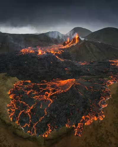
Fagradalsfjall was an effusive, not eruptive, volcano which means that lava oozed out rather than exploding with rock, fire, and ash. This made for some amazing pictures and many tourists flocked to see this amazing spectacle. Here is a short drone video of that eruption. (click here to see drone video)
Not all volcanic activity on this island nation is harmless though. In 2010 the Eyajfjallajokull eruption disrupted air traffic all over Europe due to the dense ash it produced. This was a reminder of the 1783 Lakagigr eruption which caused widespread crop failure and famine in Europe because of the dense ash plume it produced. Pictured below is a photo of one of the craters left behind from this destructive eruption.

In an area so volatile with volcanic activity it is crucial to monitor and plan what to do in the event of an eruption and the government of Iceland has many measures in place for this purpose. I found this information regarding the subject on the internet.
"Volcanic monitoring and response
Networks of seismometers and GPS stations monitor volcanic regions around Iceland. These are mainly operated by the Icelandic Meteorological Office (IMO), providing real-time data (seismic), and same-day updates on the status of deformation at selected volcanoes (the GPS-station network). A network of real-time gauging stations in glacial rivers monitor discharge and geothermal signals in the rivers. These networks are publicly accessible on the web-page of IMO (https://vedur.is). The IMO also has C- and X-band radars to track eruption plumes. Air quality and gas concentrations are monitored by the Environment Agency of Iceland. During unrest and volcanic activity, response is coordinated by the Civil Protection Department of the Icelandic Police Commissioner. During volcanic unrest and activity, expertise is sought widely and active collaboration on monitoring and assessment exists between the IMO and the Nordic Volcanological Center at the Institute of Earth Sciences, University of Iceland. An informal Science Advisory Board of the Civil Protection Department holds frequent meetings during unrest, over the last two years exclusively as online meetings." Source: https://www.consorsegurosdigital.com/
Sources:
Iceland's Volcanoes: The Complete Guide:
https://guidetoiceland.is
https://youtu.be/ubHRA2x8Hx8
Icelandic Meteorological Office:
https://en.vedur.is/
Consorseguros Vista Digital:
https://www.consorsegurosdigital.com/
Catalog of Icelandic Volcanoes:
https://icelandicvolcanos.is/#